


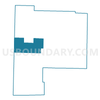
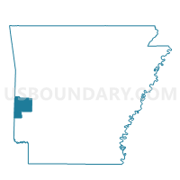
Hatfield Voting District, Polk County, Arkansas
About
Outline

Summary
| Unique Area Identifier | 527689 |
| Name | Hatfield Voting District |
| County | Polk County |
| State | Arkansas |
| Area (square miles) | 61.63 |
| Land Area (square miles) | 61.27 |
| Water Area (square miles) | 0.36 |
| % of Land Area | 99.42 |
| % of Water Area | 0.58 |
| Latitude of the Internal Point | 34.48523050 |
| Longtitude of the Internal Point | -94.36170200 |
Maps

Graphs
Select a template below for downloading or customizing gragh for Hatfield Voting District, Polk County, Arkansas


Neighbors
Neighoring Voting District (by Name) Neighboring Voting District on the Map
- Voting District 25, McCurtain County, OK
- Voting District 26, McCurtain County, OK
- Voting District 304, Le Flore County, OK
- Alder Springs Voting District, Polk County, AR
- Cove Voting District, Polk County, AR
- Mena Voting District, Polk County, AR
- Potter Voting District, Polk County, AR
- Shady Voting District, Polk County, AR
Top 10 Neighboring County Subdivision (by Population) Neighboring County Subdivision on the Map
- Center township, Polk County, AR (7,255)
- North McCurtain CCD, McCurtain County, OK (2,698)
- White township, Polk County, AR (1,976)
- Potter township, Polk County, AR (1,776)
- Cove township, Polk County, AR (1,379)
- South Le Flore CCD, Le Flore County, OK (655)
- Eagle township, Polk County, AR (615)
- Cedar township, Polk County, AR (170)
- Gap Springs township, Polk County, AR (98)
Top 10 Neighboring Place (by Population) Neighboring Place on the Map
Top 10 Neighboring Elementary School District (by Population) Neighboring Elementary School District on the Map
Top 10 Neighboring Unified School District (by Population) Neighboring Unified School District on the Map
- Mena Public Schools, AR (13,335)
- Van-Cove School District, AR (2,059)
- Smithville Public Schools, OK (1,333)
Top 10 Neighboring State Legislative District Lower Chamber (by Population) Neighboring State Legislative District Lower Chamber on the Map
- State House District 19, OK (34,076)
- State House District 1, OK (32,885)
- State House District 22, AR (26,644)
Top 10 Neighboring State Legislative District Upper Chamber (by Population) Neighboring State Legislative District Upper Chamber on the Map
- State Senate District 4, OK (78,222)
- State Senate District 20, AR (73,443)
- State Senate District 5, OK (68,974)
Top 10 Neighboring 111th Congressional District (by Population) Neighboring 111th Congressional District on the Map
Top 10 Neighboring Census Tract (by Population) Neighboring Census Tract on the Map
- Census Tract 9501, Polk County, AR (4,336)
- Census Tract 407, Le Flore County, OK (3,177)
- Census Tract 9503, Polk County, AR (2,721)
- Census Tract 982, McCurtain County, OK (2,698)
- Census Tract 9505, Polk County, AR (2,078)